Heritage Trail
To showcase the heritage of our municipality, the cultural committee and municipal council decided to create a Heritage Trail. It is 23 kilometers long.
Following the route you will discover the Stanstead Township, its built heritage and natural beauty. After your visit you will better understand why people have a strong attachment to the area.
The trail includes five stops with bilingual signs that outline some of the history of the buildings, cemeteries and characters of township. We invite you to tour by car in any season.
Biking Tour
Discover a part of Eastern Township on bike!
Narrows Bridge
The covered bridge is located on Ridgewood, via Narrows and Merrill roads. Discover this bridge built in 1881.
The Narrows Bridge takes its name from the narrowing arm of the lake dividing the upper and outer portions of the bay commonly referred to as the Narrows.
Once built it enabled a more direct route for stage coaches and travellers going between neighboring villages such as Apple Grove, Griffin’s Corners and the Vermont border.
The bridge was painted by local artist Gretchen Hatfield on the wall of the village hardware store. Here’s the story of the mural’s conception.
The Townships trails
We are proud to offer you a stopover on the Chemin des Cantons. The village of Georgeville is part of the discovery route.
Georgeville was first known as Copp’s Ferry in honor of Moses Copp who settled there with his family in 1797. Its current name dates from 1825. Located on the eastern shore of Lake Memphremagog, it was for a long time a direct link for travelers from Montreal to Boston. Its location allows it to avoid commercial tourism while its architecture heritage is of special interest, two significant features which give Georgeville its unique charm.
The Elephant Barn
Built in the late 1830s, this barn is located on Elephant Road at the corner of Magoon Point Road south of Georgeville.
During the 1930’s the main house was converted into a lodge and the barn became a restaurant. Among the visitors was an artist who painted an elephant on the barn, likely inspired by Mount Elephantis, on the other side of the lake in Potton Township.
The current owners have transformed the barn into an art gallery. It is open during the Arts Festival at the end of July. It is possible to stop and admire this property throughout the year.
Panorama Trail
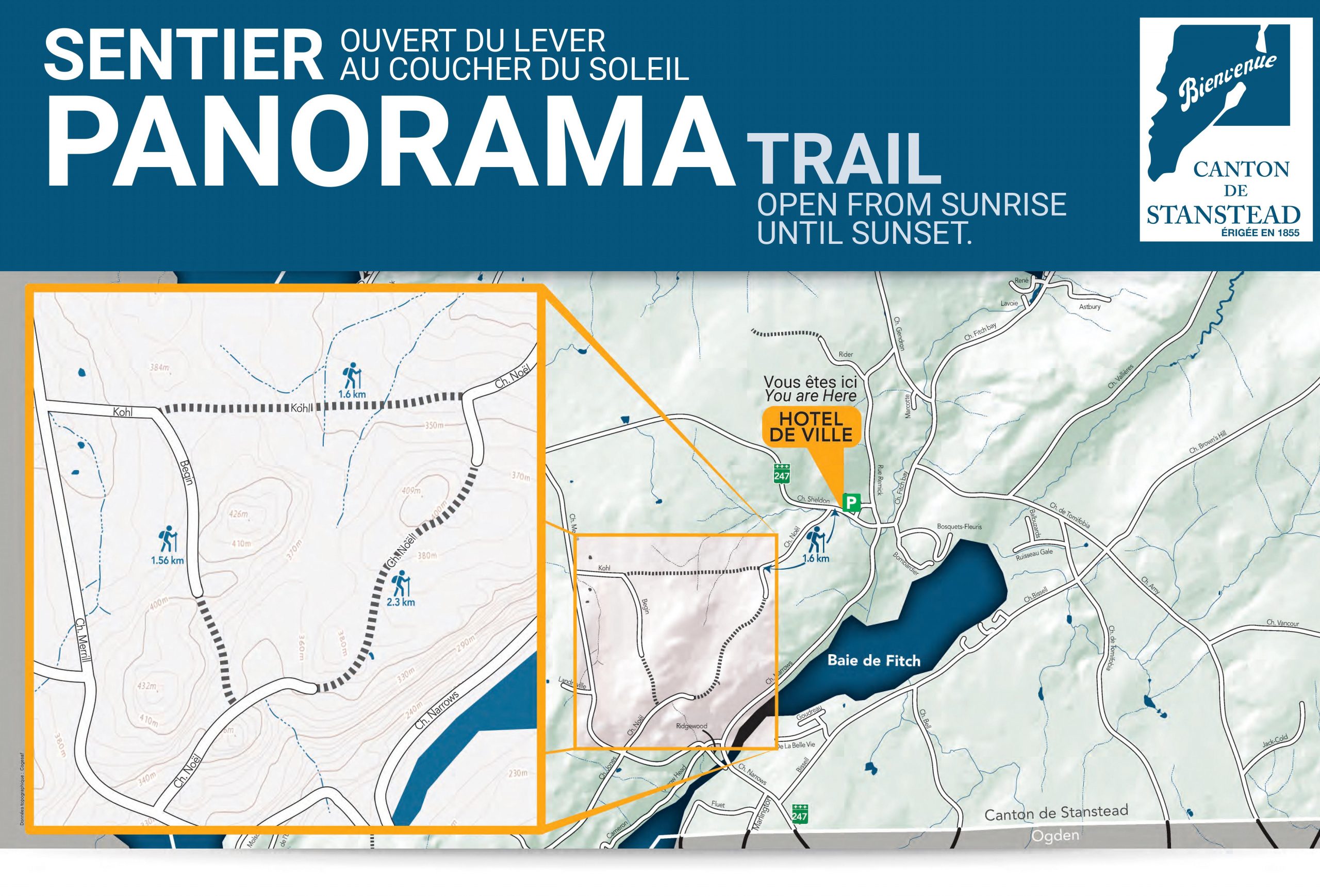
The 5.6 km trail is located on Noël, Kohl and Bégin roads and can be used by walkers, cyclists, cross-country skiers and snowshoers.
The goal of this project is to encourage citizen participation in the life of the community and to promote healthy lifestyle habits. All this in a natural and peaceful environment, which is why motorized vehicles (ATVs, snowmobiles, etc.) are not permitted.
The trail includes three segments accessible by automobile to allow waterfront property owners to access their land.
If you wish to increase the level of difficulty, we suggest that you park at the town hall and walk to the trail. This will add 1.1 km to your route. Otherwise, the trail is accessible by car, you will have the possibility to park at the roadside, at the entrances of the trail.
The trail is accessible from sunrise to sunset. As it is not maintained in winter, you will have to make your own trails.
Lines of conduct:
- Pets are welcome but must be kept on a short leash (max. 6 ft.). Please dispose of your pet’s waste;
- Motorized vehicles are not permitted on sections of the trail that are in the forest and are closed by gates;
- In respect of the environment, please only take pictures.
The Panorama Trail is the result of a collaboration between the municipality and neighbouring property owners. For this reason, we thank you for staying on the trail and respecting the guidelines.
We would like to thank the MRC Memphrémagog for their financial support under the program: Fonds de développement des territoires, projets structurants pour améliorer les milieux de vies.
****Please note that during hunting season, the trail is closed.

Copp’s Ferry Museum
Featuring the history and heritage of Georgeville and the Murray Family. Open to visitors on Saturdays from 1 to 4 pm or by appointment. Come and discover local history, art and crafts, and an exhibition of maritime artefacts. 4665, Georgeville Road. Entrance by Square’s Copp
Tel. 819-868-0866
Beach and wharf in Georgeville
Located on Square’s Copp, come and take a breath of air on this magnificent wharf and enjoy the view. Dip your toes in the waters of Lake Memphrémagog via the small beach. Public swimming dock with life guard (during the peak summer season).
Bigelow Gardens
A small garden of pioneers, which houses plants of historical interest. Entrance by Copp Square near Studio Georgeville. The garden is under the administration of the Georgeville Historical Society and maintained by village volunteers. Free. Closed in the winter.
Stewart Hopps Nature Reserve
The Stewart Hopps Nature Reserve is a wetlands about 2 km from Georgeville and 4 km from Fitch Bay. It is a project of the Memphremagog Wetlands Foundation, named in honour of its founder, the leading environmentalist Stewart Hopps, who died in 2005.
Forand Park
Forand Park is a municipal park located at the mouth of Fitch Bay. On site, a rest area and a boat ramp.
Thayer Park
Thayer Park is located in the center of Fitch Bay Village. This is a place with a gazebo perfect for a picnic with family or friends. On-site children’s game module and a multi-functional surface.